Page 4 of 4
Re: Locations? Locations! Location 125
Posted: Thu Dec 18, 2025 10:50 pm
by snowdog71
Jonty wrote: ↑Thu Dec 18, 2025 5:03 pm
Here’s three maps of the potential Ainslie Street site. The first from 1890 shows the yet to be developed land off Ainslie St to the north of the LongReins Rezzer. I would hazard a guess and say the likely location would be at the field adjacent to the reservoir as the banking at the north edge of the reservoir would have provided a banking for spectators behind a goal in that area.
The 1910 map shows some further street development, namely Titchfield Street and Newby Terrace starting to spread into that area, if it was this site, Titchfield Street would have now been placed between Ainslie St and the ground. Holker Street now on the left of the 1910 map
The last image is the site today. The reservoir long drained and used by Barrow Celtic, but, interestingly the banked up north end is still there today. Ive highlighted it and tried to envisage a pitch in that location. Centre Circle placed in someone’s garden- Newport St.
Well that’s my detective work done, could be way off but it certainly looks like the most likely location for a pitch. At that time (first map) it was the only part of Ainslie St that wasn't developed and I don't think any pitch could have been placed on the town side of Ainslie St. There are no maps from the exact years at this location, so all a bit of guess work,…unless Barrow Evening Mail archives can pinpoint the exact location.
Im gonna say that the Long reins “Rezzer” End would have been the embankment where our first fans stood. “We all live at the top of the Rezzer end” being our first chant

Jonty,
You're way off the mark.
The ground was situated on the opposite side of Ainslie Street, on Furness Railway owned land in-between the Griffin Steelworks and the initial housing development of Warwick Street, Cragg Street, West View Road & Westmorland Street.
The goal ends ran from east to west and due to the fact that the ground was only in use for 6 months, it doesn't appear on any OS maps but I have conducted a fair amount of research on the site and the Furness Railway land and have managed to roughly pinpoint the site.
I do have a rough map but I'm not tech savvy enough to post it on here.
Re: Locations? Locations! Location 125
Posted: Thu Dec 18, 2025 11:01 pm
by Jonty
Lol, guess i wont get that detective job then
. Well done on your research
Re: Locations? Locations! Location 125
Posted: Thu Dec 18, 2025 11:08 pm
by McMark
snowdog71 wrote: ↑Thu Dec 18, 2025 10:50 pm
Jonty wrote: ↑Thu Dec 18, 2025 5:03 pm
Here’s three maps of the potential Ainslie Street site. The first from 1890 shows the yet to be developed land off Ainslie St to the north of the LongReins Rezzer. I would hazard a guess and say the likely location would be at the field adjacent to the reservoir as the banking at the north edge of the reservoir would have provided a banking for spectators behind a goal in that area.
The 1910 map shows some further street development, namely Titchfield Street and Newby Terrace starting to spread into that area, if it was this site, Titchfield Street would have now been placed between Ainslie St and the ground. Holker Street now on the left of the 1910 map
The last image is the site today. The reservoir long drained and used by Barrow Celtic, but, interestingly the banked up north end is still there today. Ive highlighted it and tried to envisage a pitch in that location. Centre Circle placed in someone’s garden- Newport St.
Well that’s my detective work done, could be way off but it certainly looks like the most likely location for a pitch. At that time (first map) it was the only part of Ainslie St that wasn't developed and I don't think any pitch could have been placed on the town side of Ainslie St. There are no maps from the exact years at this location, so all a bit of guess work,…unless Barrow Evening Mail archives can pinpoint the exact location.
Im gonna say that the Long reins “Rezzer” End would have been the embankment where our first fans stood. “We all live at the top of the Rezzer end” being our first chant
Jonty,
You're way off the mark.
The ground was situated on the opposite side of Ainslie Street, on Furness Railway owned land in-between the Griffin Steelworks and the initial housing development of Warwick Street, Cragg Street, West View Road & Westmorland Street.
The goal ends ran from east to west and due to the fact that the ground was only in use for 6 months, it doesn't appear on any OS maps but I have conducted a fair amount of research on the site and the Furness Railway land and have managed to roughly pinpoint the site.
I do have a rough map but I'm not tech savvy enough to post it on here.
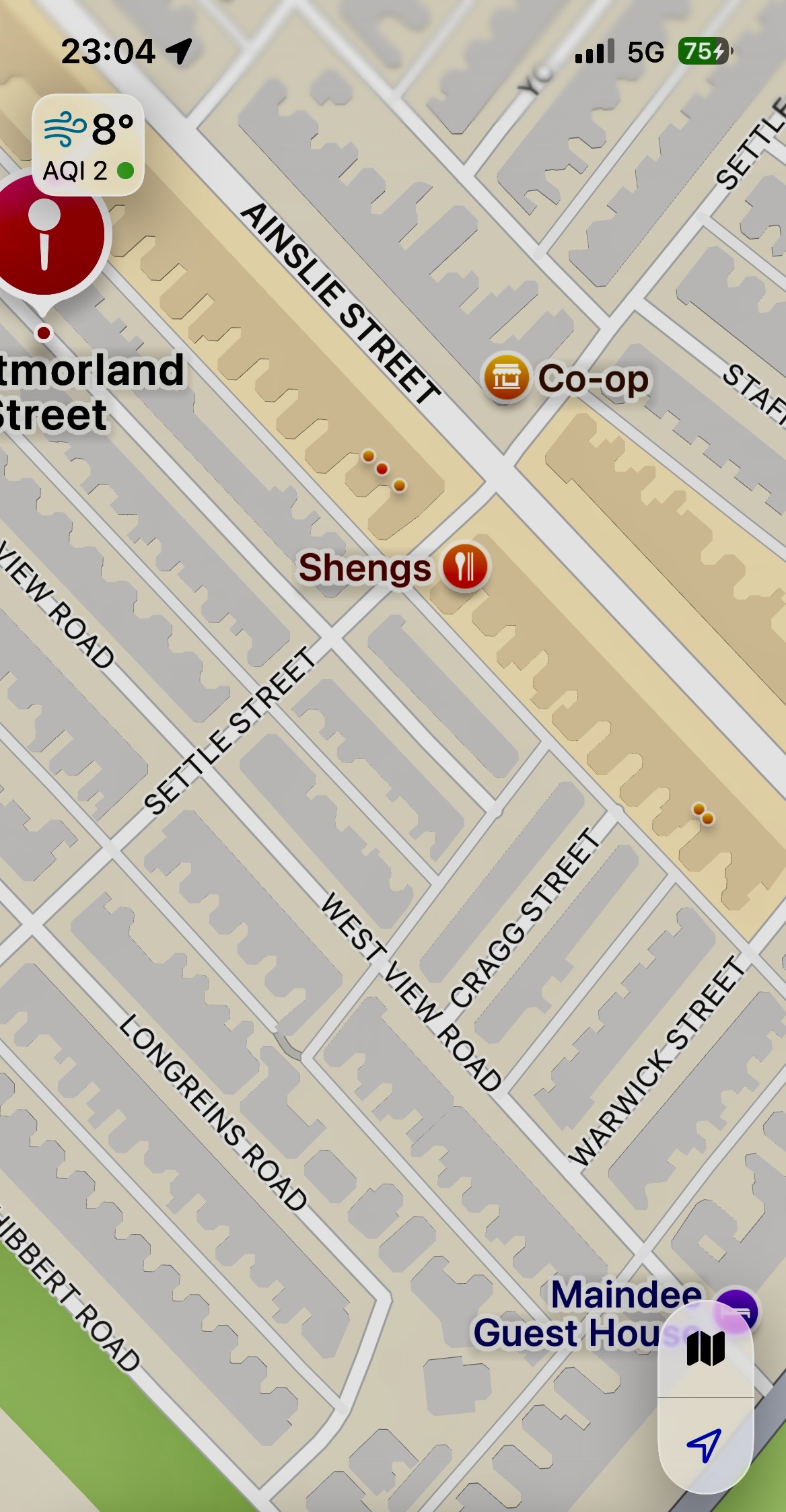
- IMG_1251.jpeg (457.13 KiB) Viewed 6003 times
Somewhere in amongst here then Peter
Re: Locations? Locations! Location 125
Posted: Thu Dec 18, 2025 11:12 pm
by snowdog71
Nearly there Mark.
If you go up to the Harrogate St junction level, then you're almost there.
It was situated between that level and Dorset Street.
Re: Locations? Locations! Location 125
Posted: Thu Dec 18, 2025 11:19 pm
by snowdog71
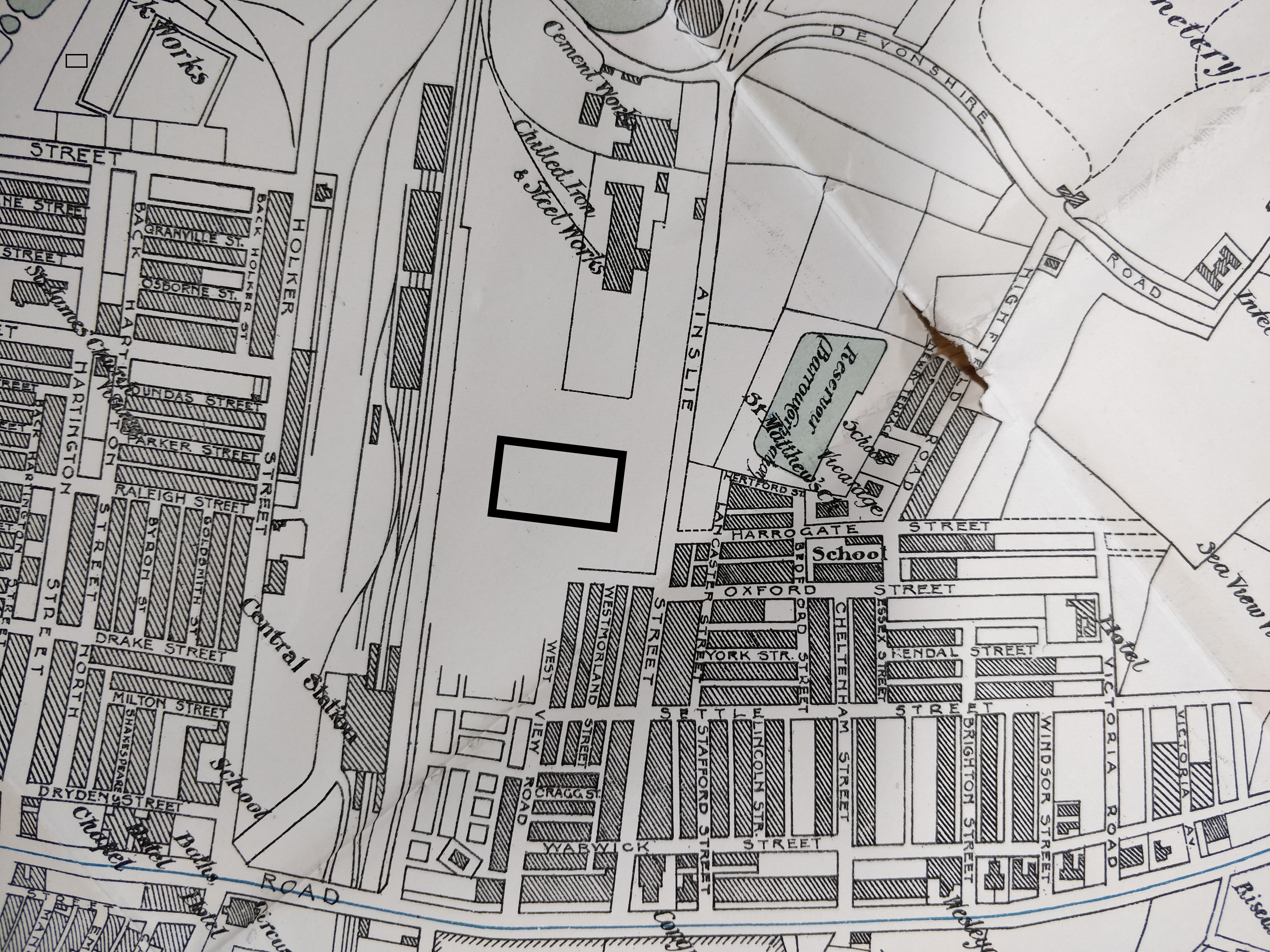
- Ainslie Street Ground Rough.jpg (2.67 MiB) Viewed 5991 times
Re: Locations? Locations! Location 125
Posted: Thu Dec 18, 2025 11:22 pm
by snowdog71
The bold rectangle indicates the most accurate available position and orientation of the pitch.
Taken from the 1902 OS Map from the Barrow Library, with my rough addition.
Re: Locations? Locations! Location 125
Posted: Thu Dec 18, 2025 11:32 pm
by McMark
snowdog71 wrote: ↑Thu Dec 18, 2025 11:22 pm
The bold rectangle indicates the most accurate available position and orientation of the pitch.
Taken from the 1902 OS Map from the Barrow Library, with my rough addition.
Thanks bud.
Re: Locations? Locations! Location 125
Posted: Fri Dec 19, 2025 10:50 pm
by Hadrian
Regarding the 'Yacht Shed' location, Walney historian Peter Laird has provided the following:
According to one source, Yacht Shed No1 was one of the covered slipways [on Walney Channel] originally intended for building large private yachts.
In ‘Portrait of a Shipbuilder’, there is a photo of Holland 1 being launched into Walney Channel.
(Peter's latest book 'Barrow: Born of Villages, Built by Industry' is available from the Archive Centre adjacent to Barrow Library, The Dock Museum, Heaths and Waterstones.)
Re: Locations? Locations! Location 125
Posted: Fri Dec 19, 2025 11:08 pm
by Barrow Lad New
Re: Locations? Locations! Location 125
Posted: Sat Dec 20, 2025 8:33 am
by barrowaberdeen
Thanks for those, very interesting.
Gathering all this into one place to work from is one of the goals of the project.
Thanks for the shed info, anyone got it on a map?
Re: Locations? Locations! Location 125
Posted: Sat Dec 20, 2025 10:51 am
by Hadrian

- Old Yacht Shed.jpg (83.35 KiB) Viewed 5703 times
Likely the building almost bottom centre on the north-east side of the channel, due east of the end of Hogue Street. For Lancashire 25" maps that I have access to at the moment, it appears for the first time on the 1910-11 revision of the 1913 edition, (Previous survey 1873-90)
